✦ Permaculture Design Programs
Three progressive paths to transform your property into a regenerative, food-producing landscape.
Each tier builds on the one below it, so you can begin where you are and grow as your goals expand.
For details on what to expect when we begin your project (Our Design Flow and how we work with you), scroll to the end.
Tier 1 · Food Forest Concept Design
$597 — Foundational Design for Home & Homestead
A concise entry-level design for families who want to begin growing food and restoring soil right away.
Built from satellite data and climate insight, this concept plan gives you clear direction without on-site measurements or engineering.
Deliverables
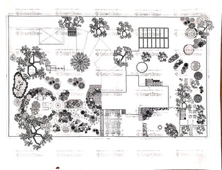
• Concept sketch showing key zones, access, planting, and water flow.
• Basic climate analysis (rainfall, temperature, aspect, seasonal data).
• Regional plant & guild list tailored to your microclimate.
• Educational starter kit (PDF guides on soil, mulch, layering, and water).
• Personalized designer video walkthrough explaining each page.
• Private client dashboard (Basecamp) for communication & downloads.
↳ Files remain available for 48 hours after delivery unless upgraded.
Best for: urban lots, suburban homes, or small homesteads ready to start planting now.
Tier 1 · Permaculture Masterplan Program
$4,997 — Comprehensive Remote Concept Design
A complete conceptual masterplan for properties of multiple acres, combining zone and sector analysis with food-forest, water, and infrastructure mapping.
This package delivers the same design quality as a full on-site plan, created remotely through data-driven mapping and client collaboration.
Deliverables (includes everything from the Food Forest Concept Design plus):
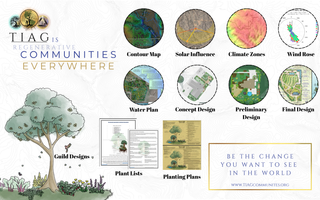
• Topographic & contour base map with boundaries and elevations.
• Sector analysis for sun, wind, water flow, microclimates, and hazards.
• Zone analysis (0 – 5) showing functional land use and access.
• Water systems plan with proposed swales, catchment, and drainage strategy.
• Food-forest planting plan and expanded guild system.
• Digital Master File set (Basecamp dashboard + download folder).
• One recorded design review session with your designer.
Best for: homesteads or acreage projects seeking a complete property-wide concept before implementation.
✦ Tier 2 · Regenerative Lens Design & Feasibility Program
$9,997 — Integrated Feasibility Studies + Full Design Suite
Includes everything in both Tier 1 programs, plus our advanced Regenerative Lens Report series.
(More details on these reports are outlined at the bottom of this listing.)
This program transforms your conceptual design into a fully feasible, data-backed regenerative strategy through detailed GIS analysis, climate modeling, and landscape-health diagnostics.
These studies inform a comprehensive and visually refined design draft for your property.
While Tier 2 provides full remote feasibility and high-resolution data accuracy, on-the-ground validation is still required for implementation-level certainty.
Additional Deliverables (on top of Tier 1 programs):
• Regenerative Lens Report (Feasibility Studies – $5,500 value) covering:
– Landscape Health & Vigor Assessment
– Resilience and Ecosystem Services Evaluation
– Connectivity & Fragmentation Mapping
– Soil and Vegetation Productivity Scores
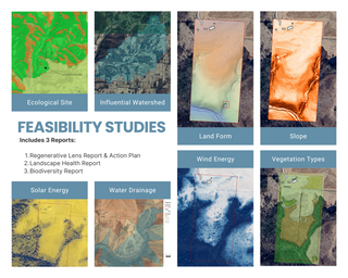
• GIS-based base maps with hydrology, slope, and watershed analysis
• Hydrology & water-flow mapping identifying pond and swale opportunities
• Thirty-year climate and insolation trend studies
• Detailed guild integration and regenerative zoning plan
• Landscape Health Index with stepwise restoration recommendations
• Extended client dashboard with long-term hosting and milestone tracking
• Optional post-design consult (video review or live strategy session)
Best for: Farms, ranches, and multi-acre projects seeking quantifiable resilience and a complete regenerative-design framework.
✦ Tier 3 · Regenerative Lens Design & Feasibility Program
$9,997 — Integrated Feasibility Studies + Full Design Suite
Ground-truthing and construction oversight are available through our Tier 3 PMC (Project Management & Consultancy) Program, which operates on an annual retainer per consultant, with travel and on-site visit fees billed separately.
The Tier 3 PMC Program is our highest-tier offering, designed as a multi-year partnership to professionally manage design, development, and implementation one season, phase, and milestone at a time.
For details, visit: (PMC) Project Management & Consultancy Program – Annual.
✦ Add-On · Master Binder Upgrade (+ $600)
Bring your design to life as a living, custom-crafted heirloom for your land and your family.
The Master Binder is not a store-bought binder—it’s a professionally printed, fully customized field manual created uniquely for your property.
Each one is designed, printed, and assembled to showcase your family’s name, crest, or logo, with your own property imagery and requested personalization inside and out.
What’s Inside
• Custom-Printed Binder Exterior – Durable, high-quality cover professionally printed with your family or farm name, logo, and property imagery.
• Tailored Internal Layout – All maps, designs, and documents printed on premium stock and organized by section—soil, water, guilds, and implementation.
• Inclusion of Client Assets – We integrate your surveys, sketches, and additional design files into the layout for a cohesive, project-specific reference.
• Homeschool & Family Learning Materials – Curated, age-appropriate lessons that teach the science behind your own land: how nitrogen-fixing plants work, what dynamic accumulators do, how bacterial relationships support soil health, and why each guild in your design functions as it does.
• Seasonal Checklists & Visual Guides – Step-by-step task pages, diagrams, and amendment recommendations tied directly to your property’s real systems.
• Digital Archive Copy – A complete digital duplicate for safekeeping, easy sharing, or future reprinting.
Each Master Binder is printed to order and hand-assembled by our design team, ensuring it becomes not just a manual, but a legacy—an educational and practical companion your family can use for generations.
Final billing may adjust if your project scope exceeds the basic print limit.
Every Design Includes
– Private client dashboard for all deliverables
– Educational and implementation resources
– Trial access to the TIAG Community
– Upgrade credit toward the next tier at any time
Catch Rain · Grow Food · Store Energy · Produce a Surplus™
Haven Permaculture LLC · in partnership with The Independent American Gardener
Feasibility Studies (Technical Appendix) · What’s Inside the Regenerative Lens Report
1. Landscape Health Report
Purpose:
Macro-level ecological and environmental context for the property.
Contents include:
- Overview of site integrity and resilience
- Quantitative data on vegetation type, slope, aspect, and soil
- Ecological site classification (e.g., Sonora–Mojave Creosotebush–White Bursage Desert Scrub)
- Land capability analysis (e.g., Jagerson very gravelly loam, Mutang–Dutchflat complex)
- Hydrology maps showing watersheds, drainage orders, and pond feasibility
- “Energy · Water · Food · Land” opportunities & constraints matrix for design decisions
- Solar and wind viability mapping
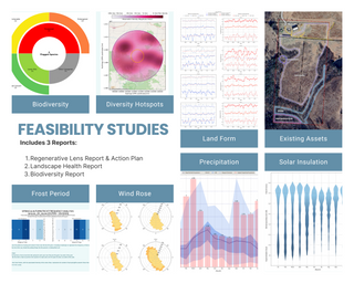
- Climate data visualizations — frost frequency, 30-year precipitation & temperature trends, insolation violin plots
- Dwelling-suitability and hazard-sector mapping (wind, dust, fire, flood)
This report forms the complete GIS + feasibility layer of your Regenerative Lens assessment.
2. Biodiversity Report
Purpose:
To document local species richness and conservation significance using open-source observation data.
Contents include:
- Explanation of taxonomic hierarchy and biodiversity data methods
- Local analysis using iNaturalist observations within 2 km & 5 km radii
- Spatial density maps of species occurrence
- Taxonomic composition charts (Kingdom → Phylum → Class)
- Top 40 most-observed species across birds, mammals, reptiles, insects, plants, and fungi
- Temporal biodiversity trend graphs showing discovery spikes
- Unique & threatened species summaries
- “Nearby species yet to be observed locally” — organisms likely present but unrecorded
Provides actionable insight for habitat restoration, pollinator corridors, and native-planting design.
3. Regenerative Lens Report
Purpose:
The synthesized feasibility & diagnostics document that integrates all preceding analyses.
Contents include:
- Consolidated GIS-based regenerative analysis (soils, slope, hydrology, solar, biodiversity)
- Landscape Health & Vigor Score with qualitative condition summary
- Ecosystem-services evaluation (water regulation, soil formation, habitat connectivity)
- Connectivity & fragmentation mapping (corridors / barriers)
- Vegetation productivity & soil-condition indices
- Recommendations for restorative interventions — windbreaks, re-vegetation, micro-basins
This document acts as the interpretive capstone — transforming raw ecological data into clear, site-specific design direction.
How They Work Together
| Layer | Role | Output Type |
|---|---|---|
| Landscape Health Report | Physical site analysis — terrain, hydrology, solar exposure, constraints | GIS visuals + climate data |
| Biodiversity Report | Ecological species inventory for habitat & planting design | Observation charts + native-species tables |
| Regenerative Lens Report | Integrative synthesis & feasibility scoring | Narrative + GIS overlays + recommendations |
Together, these three deliverables make up the Regenerative Lens (Feasibility Studies) portion of the Tier 2 Program, valued at $5,500 within our pricing model.
